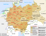
File:Administrative divisions of Germany, February 1944.png
From Wikimedia Commons, the free media repository
Jump to navigation
Jump to search

Size of this preview: 773 × 600 pixels. Other resolutions: 310 × 240 pixels | 619 × 480 pixels | 990 × 768 pixels | 1,280 × 993 pixels | 2,607 × 2,022 pixels.
Original file (2,607 × 2,022 pixels, file size: 577 KB, MIME type: image/png)
File information
Structured data
Captions
Captions
Add a one-line explanation of what this file represents
Summary[edit]
| DescriptionAdministrative divisions of Germany, February 1944.png |
English: Map of the NSDAP administrative divisions of Germany, February 1944.
Deutsch: Englischsprachige Karte der administrative Gliederung des Großdeutschen Reiches durch die NSDAP 1944.
Polski: Mapa Wielkiej Rzeszy Niemieckiej (1944) |
||||
| Date | |||||
| Source | File:Grossdeutsches_Reich_NS_Administration_1944.png | ||||
| Author | DIREKTOR (derived from Exec's file) | ||||
| Permission (Reusing this file) |
This file is licensed under the Creative Commons Attribution-Share Alike 4.0 International license.
|
||||
| Other versions |
|
File history
Click on a date/time to view the file as it appeared at that time.
| Date/Time | Thumbnail | Dimensions | User | Comment | |
|---|---|---|---|---|---|
| current | 12:25, 8 October 2021 |  | 2,607 × 2,022 (577 KB) | Kamilhrub (talk | contribs) | Corrected border of Lublin and Galicia districts, which didn't change after 1941 (source: Amtliches Gemeinde- und Dorfverzeichnis für das Generalgouvernement auf Grund der Summarischen Bevölkerungsbestandsaufnahme am 1. März 1943) |
| 05:36, 5 February 2017 |  | 2,607 × 2,022 (563 KB) | DIREKTOR (talk | contribs) | Legend frames. | |
| 13:23, 4 February 2017 |  | 2,607 × 2,022 (563 KB) | DIREKTOR (talk | contribs) | Further error corrections ("Francfort", "Berne", etc.) | |
| 11:08, 4 February 2017 |  | 2,607 × 2,022 (594 KB) | DIREKTOR (talk | contribs) | Error corrections. | |
| 12:49, 3 February 2017 |  | 2,607 × 2,022 (614 KB) | DIREKTOR (talk | contribs) | User created page with UploadWizard |
You cannot overwrite this file.
File usage on Commons
The following page uses this file:
Metadata
This file contains additional information such as Exif metadata which may have been added by the digital camera, scanner, or software program used to create or digitize it. If the file has been modified from its original state, some details such as the timestamp may not fully reflect those of the original file. The timestamp is only as accurate as the clock in the camera, and it may be completely wrong.
| Horizontal resolution | 72 dpi |
|---|---|
| Vertical resolution | 72 dpi |
| Color space | sRGB |
| Image width | 2,607 px |
| Image height | 2,022 px |
| Software used | Adobe Photoshop CC 2014 (Windows) |
| Date and time of digitizing | 14:45, 3 February 2017 |
| Date metadata was last modified | 07:34, 5 February 2017 |
| File change date and time | 07:34, 5 February 2017 |
| Unique ID of original document | xmp.did:c3f2d99e-5833-994f-98b9-6eb23b9c68d5 |

